


Rando Dudu du 23/02/2019

dudu85
Gebruiker
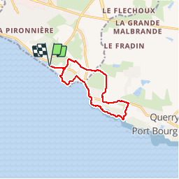

Lengte
10,6 km

Max. hoogte
30 m

Positief hoogteverschil
105 m
Km-Effort
12 km

Min. hoogte
1 m

Negatief hoogteverschil
105 m
Boucle
Ja
Datum van aanmaak :
2019-02-23 10:48:48.0
Laatste wijziging :
2019-03-03 10:03:49.744
2h46
Moeilijkheid : Onbekend

Gratisgps-wandelapplicatie
 SityTrail
IGN / Geografische instituten
SityTrail Plus
De wereld gaat voor u open
Over ons
Tocht Stappen van 10,6 km beschikbaar op Pays de la Loire, Vendée, Les Sables-d'Olonne. Deze tocht wordt voorgesteld door dudu85.
Beschrijving
Avec JP & Maryse
Plaatsbepaling
Land:
France
Regio :
Pays de la Loire
Departement/Provincie :
Vendée
Gemeente :
Les Sables-d'Olonne
Locatie:
Château-d'Olonne
Vertrek:(Dec)
Vertrek:(UTM)
597425 ; 5146425 (30T) N.
Opmerkingen